Mount St. Helens
By: Madalyn Frank
Mount St. Helen's is in Skamania county, Washington. The mountain is 96 miles away from Seattle at the coordinates 46.1912 north and 122.1944 west.
Mount St. Helen's is formed at a convergent boundary were the North American plate and the Juan de Fuca plate collide.
1980 eruption
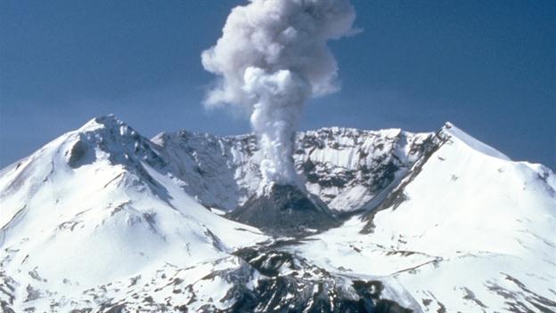
In 1980 the mountain erupted. Everything within a 230 mile radius was killed. This includes 57 people. The mountain kept erupting for nine hours and there was so much ash. The most ash came from this eruption because the peak collapsed 1,313 feet and so much ash came from that.
History
The mountain is so old and has gone off so many times before the eruption in 1980 and has even gone off since then. I think what made the 1980 eruption the biggest is the landslide that caused so much more ash.
The mountain lost 14% of its height from the 1980 eruption.
Sources:
- N.p., n.d. Web. <http%3A%2F%2Fwww.dnr.wa.gov%2FResearchScience%2FTopics%2FGeologicHazardsMapping%2FPages%2Fearthquakes.aspx>.
"Image." Image. N.p., n.d. Web. <http://volcanoes.usgs.gov/observatories/cvo/Historical/LewisClark/Historical/corps-engineers-archives_mount_st_helens_1978.jpg>.
"Mount St. Helens Erupts Video." History.com. A&E Television Networks, n.d. Web. 12 Mar. 2015. <http://www.history.com/topics/us-states/washington/videos/mount-st-helens-erupts?m=528e394da93ae&s=undefined&f=1&free=false>.
http://beforeitsnews.com/mediadrop/uploads/2014/19/b9e6b0a25efb81f1c820f97eaebb041eff7fa62d.jpg
"Pre-1980 Eruptive History of Mount St. Helens, Washington | USGS Fact Sheet 2005-3045." Pre-1980 Eruptive History of Mount St. Helens, Washington | USGS Fact Sheet 2005-3045. N.p., n.d. Web. 12 Mar. 2015. <http://pubs.usgs.gov/fs/2005/3045/>.